Hi there!
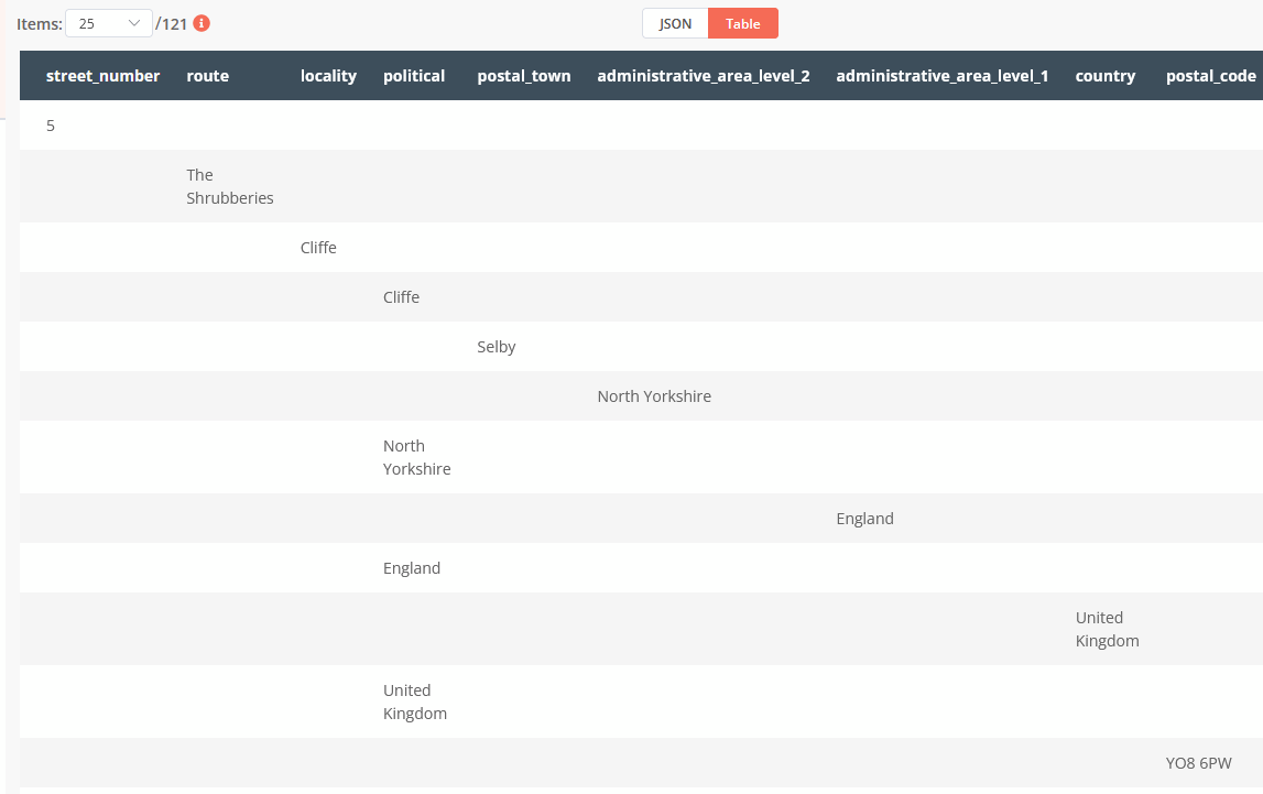
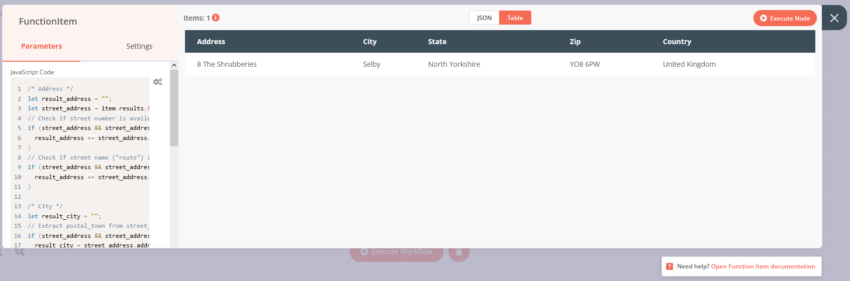
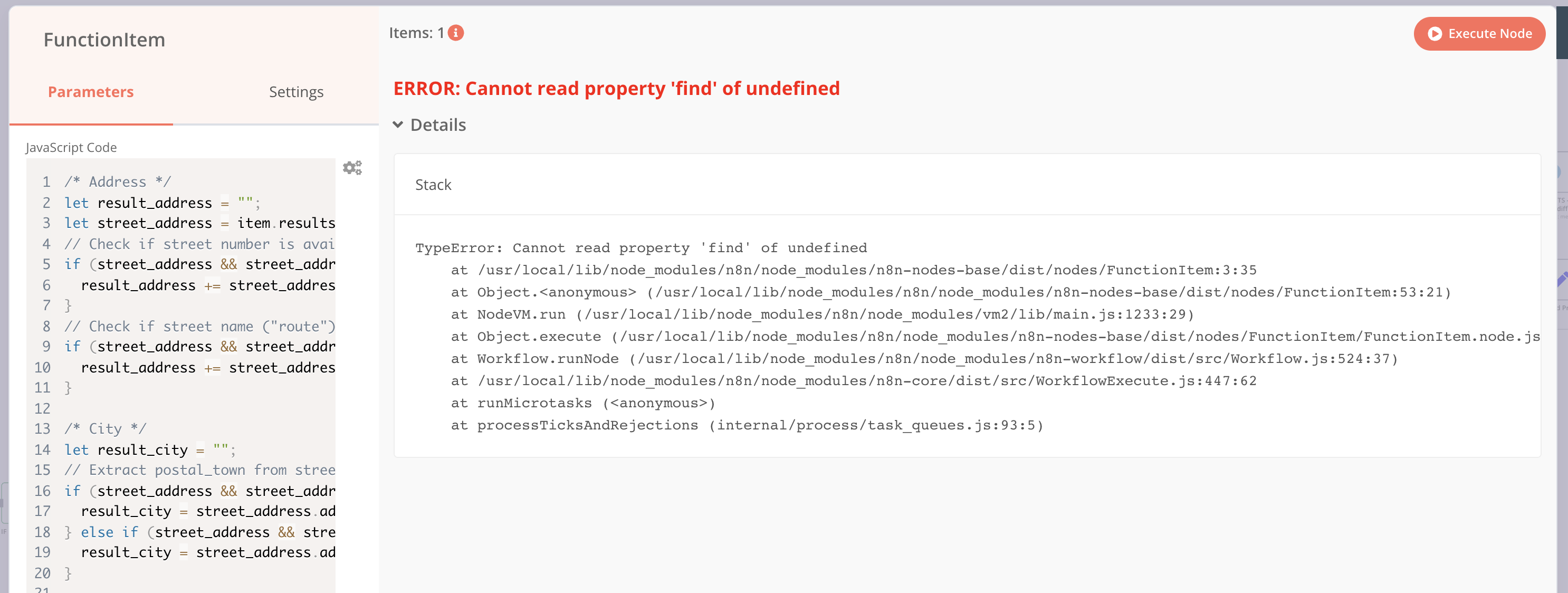
I have a HTTP request Node which queries Google Maps API and returns address data (example output below). I need to access the address_components fields so I can structure the address correctly in a database.
How can I run through this data, and output the long_names as values with the ‘types’ as the keys?
I’ve found a few scripts online that appear to do something similar (How to parse google maps Address components. (geocoder response) | by Ahmed Ali Thabet | Medium) and don’t think it can be that difficult but can’t for the life of me get them to work when I paste into a Function Node and attempt to access via items. Can anyone please help me?
[{
  "plus_code": {
    "compound_code": "Q2G3+XXP Selby, UK",
    "global_code": "9C5XQ2G3+XXP"
  },
  "results": [{
    "address_components": [{
      "long_name": "5",
      "short_name": "5",
      "types": [
        "street_number"
      ]
    },
    {
      "long_name": "The Shrubberies",
      "short_name": "The Shrubberies",
      "types": [
        "route"
      ]
    },
    {
      "long_name": "Cliffe",
      "short_name": "Cliffe",
      "types": [
        "locality",
        "political"
      ]
    },
    {
      "long_name": "Selby",
      "short_name": "Selby",
      "types": [
        "postal_town"
      ]
    },
    {
      "long_name": "North Yorkshire",
      "short_name": "North Yorkshire",
      "types": [
        "administrative_area_level_2",
        "political"
      ]
    },
    {
      "long_name": "England",
      "short_name": "England",
      "types": [
        "administrative_area_level_1",
        "political"
      ]
    },
    {
      "long_name": "United Kingdom",
      "short_name": "GB",
      "types": [
        "country",
        "political"
      ]
    },
    {
      "long_name": "YO8 6PW",
      "short_name": "YO8 6PW",
      "types": [
        "postal_code"
      ]
    }
  ],
  "formatted_address": "5 The Shrubberies, Cliffe, Selby YO8 6PW, UK",
  "geometry": {
    "bounds": {
      "northeast": {
        "lat": 53.7776495,
        "lng": -0.9949507999999999
      },
      "southwest": {
        "lat": 53.7775064,
        "lng": -0.9951573
      }
    },
    "location": {
      "lat": 53.7775733,
      "lng": -0.9950642999999999
    },
    "location_type": "ROOFTOP",
    "viewport": {
      "northeast": {
        "lat": 53.7789269302915,
        "lng": -0.9937050697084978
      },
      "southwest": {
        "lat": 53.7762289697085,
        "lng": -0.9964030302915019
      }
    }
  },
  "place_id": "ChIJ52OBwh0jeUgRAaAPAnafIZY",
  "types": [
    "premise"
  ]
},
{
  "address_components": [{
    "long_name": "8",
    "short_name": "8",
    "types": [
      "street_number"
    ]
  },
  {
    "long_name": "The Shrubberies",
    "short_name": "The Shrubberies",
    "types": [
      "route"
    ]
  },
  {
    "long_name": "Cliffe",
    "short_name": "Cliffe",
    "types": [
      "locality",
      "political"
    ]
  },
  {
    "long_name": "Selby",
    "short_name": "Selby",
    "types": [
      "postal_town"
    ]
  },
  {
    "long_name": "North Yorkshire",
    "short_name": "North Yorkshire",
    "types": [
      "administrative_area_level_2",
      "political"
    ]
  },
  {
    "long_name": "England",
    "short_name": "England",
    "types": [
      "administrative_area_level_1",
      "political"
    ]
  },
  {
    "long_name": "United Kingdom",
    "short_name": "GB",
    "types": [
      "country",
      "political"
    ]
  },
  {
    "long_name": "YO8 6PW",
    "short_name": "YO8 6PW",
    "types": [
      "postal_code"
    ]
  }
],
"formatted_address": "8 The Shrubberies, Cliffe, Selby YO8 6PW, UK",
"geometry": {
  "location": {
    "lat": 53.7775616,
    "lng": -0.9949786
  },
  "location_type": "ROOFTOP",
  "viewport": {
    "northeast": {
      "lat": 53.7789105802915,
      "lng": -0.993629619708498
    },
    "southwest": {
      "lat": 53.7762126197085,
      "lng": -0.996327580291502
    }
  }
},
"place_id": "ChIJV9Be2h0jeUgRZMzUX0q07ME",
"plus_code": {
  "compound_code": "Q2H4+22 Selby, UK",
  "global_code": "9C5XQ2H4+22"
},
"types": [
  "street_address"
]
},
{
  "address_components": [{
    "long_name": "The Shrubberies",
    "short_name": "The Shrubberies",
    "types": [
      "establishment",
      "point_of_interest",
      "transit_station"
    ]
  },
  {
    "long_name": "Cliffe",
    "short_name": "Cliffe",
    "types": [
      "locality",
      "political"
    ]
  },
  {
    "long_name": "Selby",
    "short_name": "Selby",
    "types": [
      "postal_town"
    ]
  },
  {
    "long_name": "North Yorkshire",
    "short_name": "North Yorkshire",
    "types": [
      "administrative_area_level_2",
      "political"
    ]
  },
  {
    "long_name": "England",
    "short_name": "England",
    "types": [
      "administrative_area_level_1",
      "political"
    ]
  },
  {
    "long_name": "United Kingdom",
    "short_name": "GB",
    "types": [
      "country",
      "political"
    ]
  },
  {
    "long_name": "YO8 6NH",
    "short_name": "YO8 6NH",
    "types": [
      "postal_code"
    ]
  }
],
"formatted_address": "The Shrubberies, Cliffe, Selby YO8 6NH, UK",
"geometry": {
  "location": {
    "lat": 53.777054,
    "lng": -0.994312
  },
  "location_type": "GEOMETRIC_CENTER",
  "viewport": {
    "northeast": {
      "lat": 53.7784029802915,
      "lng": -0.9929630197084979
    },
    "southwest": {
      "lat": 53.7757050197085,
      "lng": -0.995660980291502
    }
  }
},
"place_id": "ChIJzx4gkx0jeUgRfAYg3nLwVJc",
"plus_code": {
  "compound_code": "Q2G4+R7 Selby, UK",
  "global_code": "9C5XQ2G4+R7"
},
"types": [
  "establishment",
  "point_of_interest",
  "transit_station"
]
},
{
  "address_components": [{
    "long_name": "Q2G3+XX",
    "short_name": "Q2G3+XX",
    "types": [
      "plus_code"
    ]
  },
  {
    "long_name": "Selby",
    "short_name": "Selby",
    "types": [
      "postal_town"
    ]
  },
  {
    "long_name": "England",
    "short_name": "England",
    "types": [
      "administrative_area_level_1",
      "political"
    ]
  },
  {
    "long_name": "United Kingdom",
    "short_name": "GB",
    "types": [
      "country",
      "political"
    ]
  }
],
"formatted_address": "Q2G3+XX Selby, UK",
"geometry": {
  "bounds": {
    "northeast": {
      "lat": 53.7775,
      "lng": -0.9949999999999999
    },
    "southwest": {
      "lat": 53.777375,
      "lng": -0.995125
    }
  },
  "location": {
    "lat": 53.77745900000001,
    "lng": -0.995035
  },
  "location_type": "GEOMETRIC_CENTER",
  "viewport": {
    "northeast": {
      "lat": 53.77878648029149,
      "lng": -0.993713519708498
    },
    "southwest": {
      "lat": 53.77608851970849,
      "lng": -0.9964114802915021
    }
  }
},
"place_id": "GhIJjn3JxoPjSkAR8wLso1PX778",
"plus_code": {
  "compound_code": "Q2G3+XX Selby, UK",
  "global_code": "9C5XQ2G3+XX"
},
"types": [
  "plus_code"
]
},
{
  "address_components": [{
    "long_name": "1-38",
    "short_name": "1-38",
    "types": [
      "street_number"
    ]
  },
  {
    "long_name": "The Shrubberies",
    "short_name": "The Shrubberies",
    "types": [
      "route"
    ]
  },
  {
    "long_name": "Cliffe",
    "short_name": "Cliffe",
    "types": [
      "locality",
      "political"
    ]
  },
  {
    "long_name": "Selby",
    "short_name": "Selby",
    "types": [
      "postal_town"
    ]
  },
  {
    "long_name": "North Yorkshire",
    "short_name": "North Yorkshire",
    "types": [
      "administrative_area_level_2",
      "political"
    ]
  },
  {
    "long_name": "England",
    "short_name": "England",
    "types": [
      "administrative_area_level_1",
      "political"
    ]
  },
  {
    "long_name": "United Kingdom",
    "short_name": "GB",
    "types": [
      "country",
      "political"
    ]
  },
  {
    "long_name": "YO8",
    "short_name": "YO8",
    "types": [
      "postal_code",
      "postal_code_prefix"
    ]
  }
],
"formatted_address": "1-38 The Shrubberies, Cliffe, Selby YO8, UK",
"geometry": {
  "bounds": {
    "northeast": {
      "lat": 53.77829819999999,
      "lng": -0.9947021999999999
    },
    "southwest": {
      "lat": 53.7770666,
      "lng": -0.9961247000000001
    }
  },
  "location": {
    "lat": 53.7780139,
    "lng": -0.9948007
  },
  "location_type": "GEOMETRIC_CENTER",
  "viewport": {
    "northeast": {
      "lat": 53.7790313802915,
      "lng": -0.9940644697084979
    },
    "southwest": {
      "lat": 53.7763334197085,
      "lng": -0.996762430291502
    }
  }
},
"place_id": "ChIJK6MF3R0jeUgRgBN8BloTElQ",
"types": [
  "route"
]
},
{
  "address_components": [{
    "long_name": "YO8 6PW",
    "short_name": "YO8 6PW",
    "types": [
      "postal_code"
    ]
  },
  {
    "long_name": "The Shrubberies",
    "short_name": "The Shrubberies",
    "types": [
      "route"
    ]
  },
  {
    "long_name": "Cliffe",
    "short_name": "Cliffe",
    "types": [
      "locality",
      "political"
    ]
  },
  {
    "long_name": "Selby",
    "short_name": "Selby",
    "types": [
      "postal_town"
    ]
  },
  {
    "long_name": "North Yorkshire",
    "short_name": "North Yorkshire",
    "types": [
      "administrative_area_level_2",
      "political"
    ]
  },
  {
    "long_name": "England",
    "short_name": "England",
    "types": [
      "administrative_area_level_1",
      "political"
    ]
  },
  {
    "long_name": "United Kingdom",
    "short_name": "GB",
    "types": [
      "country",
      "political"
    ]
  }
],
"formatted_address": "The Shrubberies, Cliffe, Selby YO8 6PW, UK",
"geometry": {
  "bounds": {
    "northeast": {
      "lat": 53.7800042,
      "lng": -0.9946520999999999
    },
    "southwest": {
      "lat": 53.7766193,
      "lng": -0.9963685999999999
    }
  },
  "location": {
    "lat": 53.7781428,
    "lng": -0.9954843000000001
  },
  "location_type": "APPROXIMATE",
  "viewport": {
    "northeast": {
      "lat": 53.7800042,
      "lng": -0.9941613697084978
    },
    "southwest": {
      "lat": 53.7766193,
      "lng": -0.9968593302915019
    }
  }
},
"place_id": "ChIJrRz22h0jeUgRbnV5W211As4",
"types": [
  "postal_code"
]
},
{
  "address_components": [{
    "long_name": "Cliffe",
    "short_name": "Cliffe",
    "types": [
      "locality",
      "political"
    ]
  },
  {
    "long_name": "Selby",
    "short_name": "Selby",
    "types": [
      "postal_town"
    ]
  },
  {
    "long_name": "North Yorkshire",
    "short_name": "North Yorkshire",
    "types": [
      "administrative_area_level_2",
      "political"
    ]
  },
  {
    "long_name": "England",
    "short_name": "England",
    "types": [
      "administrative_area_level_1",
      "political"
    ]
  },
  {
    "long_name": "United Kingdom",
    "short_name": "GB",
    "types": [
      "country",
      "political"
    ]
  },
  {
    "long_name": "YO8",
    "short_name": "YO8",
    "types": [
      "postal_code",
      "postal_code_prefix"
    ]
  }
],
"formatted_address": "Cliffe, Selby YO8, UK",
"geometry": {
  "bounds": {
    "northeast": {
      "lat": 53.7899617,
      "lng": -0.9883202
    },
    "southwest": {
      "lat": 53.774036,
      "lng": -1.0044702
    }
  },
  "location": {
    "lat": 53.7800142,
    "lng": -0.9971095000000001
  },
  "location_type": "APPROXIMATE",
  "viewport": {
    "northeast": {
      "lat": 53.7899617,
      "lng": -0.9883202
    },
    "southwest": {
      "lat": 53.774036,
      "lng": -1.0044702
    }
  }
},
"place_id": "ChIJ_5S7aicjeUgRtMVpoiaR8qE",
"types": [
  "locality",
  "political"
]
},
{
  "address_components": [{
    "long_name": "Cliffe",
    "short_name": "Cliffe",
    "types": [
      "administrative_area_level_4",
      "political"
    ]
  },
  {
    "long_name": "Selby",
    "short_name": "Selby",
    "types": [
      "postal_town"
    ]
  },
  {
    "long_name": "North Yorkshire",
    "short_name": "North Yorkshire",
    "types": [
      "administrative_area_level_2",
      "political"
    ]
  },
  {
    "long_name": "England",
    "short_name": "England",
    "types": [
      "administrative_area_level_1",
      "political"
    ]
  },
  {
    "long_name": "United Kingdom",
    "short_name": "GB",
    "types": [
      "country",
      "political"
    ]
  },
  {
    "long_name": "YO8",
    "short_name": "YO8",
    "types": [
      "postal_code",
      "postal_code_prefix"
    ]
  }
],
"formatted_address": "Cliffe, Selby YO8, UK",
"geometry": {
  "bounds": {
    "northeast": {
      "lat": 53.8218872,
      "lng": -0.9341634999999999
    },
    "southwest": {
      "lat": 53.7598041,
      "lng": -1.0365264
    }
  },
  "location": {
    "lat": 53.7925714,
    "lng": -0.9836201000000001
  },
  "location_type": "APPROXIMATE",
  "viewport": {
    "northeast": {
      "lat": 53.8218872,
      "lng": -0.9341634999999999
    },
    "southwest": {
      "lat": 53.7598041,
      "lng": -1.0365264
    }
  }
},
"place_id": "ChIJY4aH6Q4jeUgR0B9t7Z75DAU",
"types": [
  "administrative_area_level_4",
  "political"
]
},
{
  "address_components": [{
    "long_name": "YO8",
    "short_name": "YO8",
    "types": [
      "postal_code",
      "postal_code_prefix"
    ]
  },
  {
    "long_name": "Selby",
    "short_name": "Selby",
    "types": [
      "postal_town"
    ]
  },
  {
    "long_name": "England",
    "short_name": "England",
    "types": [
      "administrative_area_level_1",
      "political"
    ]
  },
  {
    "long_name": "United Kingdom",
    "short_name": "GB",
    "types": [
      "country",
      "political"
    ]
  }
],
"formatted_address": "Selby YO8, UK",
"geometry": {
  "bounds": {
    "northeast": {
      "lat": 53.8620955,
      "lng": -0.8143208
    },
    "southwest": {
      "lat": 53.700854,
      "lng": -1.1939887
    }
  },
  "location": {
    "lat": 53.7978369,
    "lng": -1.0032842
  },
  "location_type": "APPROXIMATE",
  "viewport": {
    "northeast": {
      "lat": 53.8620955,
      "lng": -0.8143208
    },
    "southwest": {
      "lat": 53.700854,
      "lng": -1.1939887
    }
  }
},
"place_id": "ChIJj20O6gEWeUgR1phll-wRyls",
"types": [
  "postal_code",
  "postal_code_prefix"
]
},
{
  "address_components": [{
    "long_name": "Selby",
    "short_name": "Selby",
    "types": [
      "postal_town"
    ]
  },
  {
    "long_name": "England",
    "short_name": "England",
    "types": [
      "administrative_area_level_1",
      "political"
    ]
  },
  {
    "long_name": "United Kingdom",
    "short_name": "GB",
    "types": [
      "country",
      "political"
    ]
  }
],
"formatted_address": "Selby, UK",
"geometry": {
  "bounds": {
    "northeast": {
      "lat": 53.85938239999999,
      "lng": -0.8253381
    },
    "southwest": {
      "lat": 53.7009007,
      "lng": -1.1955835
    }
  },
  "location": {
    "lat": 53.7978369,
    "lng": -1.0032842
  },
  "location_type": "APPROXIMATE",
  "viewport": {
    "northeast": {
      "lat": 53.85938239999999,
      "lng": -0.8253381
    },
    "southwest": {
      "lat": 53.7009007,
      "lng": -1.1955835
    }
  }
},
"place_id": "ChIJW-phvyYjeUgRp4YN5SPtn3M",
"types": [
  "postal_town"
]
},
{
  "address_components": [{
    "long_name": "Selby",
    "short_name": "Selby",
    "types": [
      "administrative_area_level_3",
      "political"
    ]
  },
  {
    "long_name": "North Yorkshire",
    "short_name": "North Yorkshire",
    "types": [
      "administrative_area_level_2",
      "political"
    ]
  },
  {
    "long_name": "England",
    "short_name": "England",
    "types": [
      "administrative_area_level_1",
      "political"
    ]
  },
  {
    "long_name": "United Kingdom",
    "short_name": "GB",
    "types": [
      "country",
      "political"
    ]
  }
],
"formatted_address": "Selby, UK",
"geometry": {
  "bounds": {
    "northeast": {
      "lat": 53.935584,
      "lng": -0.9034008
    },
    "southwest": {
      "lat": 53.6210943,
      "lng": -1.3529652
    }
  },
  "location": {
    "lat": 53.7867568,
    "lng": -1.0677977
  },
  "location_type": "APPROXIMATE",
  "viewport": {
    "northeast": {
      "lat": 53.935584,
      "lng": -0.9034008
    },
    "southwest": {
      "lat": 53.6210943,
      "lng": -1.3529652
    }
  }
},
"place_id": "ChIJRzjbpCs8eUgRQONs7Z75DAQ",
"types": [
  "administrative_area_level_3",
  "political"
]
},
{
  "address_components": [{
    "long_name": "North Yorkshire",
    "short_name": "North Yorkshire",
    "types": [
      "administrative_area_level_2",
      "political"
    ]
  },
  {
    "long_name": "England",
    "short_name": "England",
    "types": [
      "administrative_area_level_1",
      "political"
    ]
  },
  {
    "long_name": "United Kingdom",
    "short_name": "GB",
    "types": [
      "country",
      "political"
    ]
  }
],
"formatted_address": "North Yorkshire, UK",
"geometry": {
  "bounds": {
    "northeast": {
      "lat": 54.56214379999999,
      "lng": -0.2123533
    },
    "southwest": {
      "lat": 53.6210943,
      "lng": -2.5647389
    }
  },
  "location": {
    "lat": 53.9915028,
    "lng": -1.5412015
  },
  "location_type": "APPROXIMATE",
  "viewport": {
    "northeast": {
      "lat": 54.56214379999999,
      "lng": -0.2123533
    },
    "southwest": {
      "lat": 53.6210943,
      "lng": -2.5647389
    }
  }
},
"place_id": "ChIJ8WWY4UDDeEgRt5-VyBki4MM",
"types": [
  "administrative_area_level_2",
  "political"
]
},
{
  "address_components": [{
    "long_name": "England",
    "short_name": "England",
    "types": [
      "administrative_area_level_1",
      "political"
    ]
  },
  {
    "long_name": "United Kingdom",
    "short_name": "GB",
    "types": [
      "country",
      "political"
    ]
  }
],
"formatted_address": "England, UK",
"geometry": {
  "bounds": {
    "northeast": {
      "lat": 55.81165979999999,
      "lng": 1.7629159
    },
    "southwest": {
      "lat": 49.8647411,
      "lng": -6.4185458
    }
  },
  "location": {
    "lat": 52.3555177,
    "lng": -1.1743197
  },
  "location_type": "APPROXIMATE",
  "viewport": {
    "northeast": {
      "lat": 55.81165979999999,
      "lng": 1.7629159
    },
    "southwest": {
      "lat": 49.8647411,
      "lng": -6.4185458
    }
  }
},
"place_id": "ChIJ39UebIqp0EcRqI4tMyWV4fQ",
"types": [
  "administrative_area_level_1",
  "political"
]
},
{
  "address_components": [{
    "long_name": "United Kingdom",
    "short_name": "GB",
    "types": [
      "country",
      "political"
    ]
    }],
    "formatted_address": "United Kingdom",
    "geometry": {
      "bounds": {
        "northeast": {
          "lat": 60.91569999999999,
          "lng": 33.9165549
        },
        "southwest": {
          "lat": 34.5614,
          "lng": -8.8988999
        }
      },
      "location": {
        "lat": 55.378051,
        "lng": -3.435973
      },
      "location_type": "APPROXIMATE",
      "viewport": {
        "northeast": {
          "lat": 60.91569999999999,
          "lng": 33.9165549
        },
        "southwest": {
          "lat": 34.5614,
          "lng": -8.8988999
        }
      }
    },
    "place_id": "ChIJqZHHQhE7WgIReiWIMkOg-MQ",
    "types": [
      "country",
      "political"
    ]
  }
],
"status": "OK"
}]